February 15, 2017
#1799: Bad Map Projection: Time Zones explain

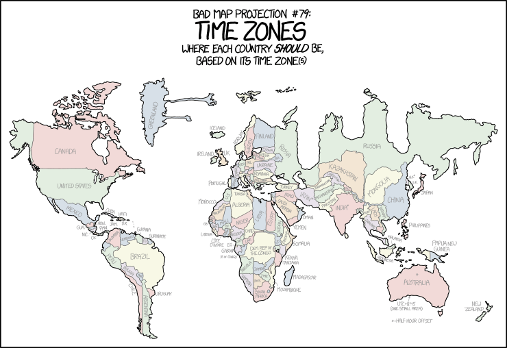
Bad map projection #79:
Time Zones
Where each country should be,
based on its time zone(s)
[A world map is shown divided and colored by political boundaries. There are many distortions, and especially Russia looks weird. Many countries have their name listed in a gray font and at the bottom below Australia there are two specialties mentioned for time zones which are not divided in full hours. One of these is a footnote used by other countries as well.]
[The labels are listed here in order of the “continents” as they come from top left to down right. Similarly within each continent’s list the countries which are usually said to belong to a given continent (at least politically or partially, e.g. Greenland and Turkey in Europe) are listed in a similar reading order as accurately as possible.]
[North America. (Newfoundland, the most easterly part of Canada, is labeled with a star *):]
Canada, *, United States, Mexico, Gua., Hon., Nic., C.R., Pan., Cuba, Haiti, Jam., D.R.
[South America:]
Colombia, Venezuela, Guyana, F.G., Suriname, Peru, Brazil, Bolivia, Par., Chile, Argentina, Uruguay
[Europe. (Russia is as the only country mentioned twice, the other place is over the central part in the Asia section):]
Greenland, Iceland, Norway, Sweden, Finland, Ireland, UK, Lithuania, Latvia, Estonia, Bel., Russia, Ger., Pol., Ukraine, France, It., Romania, Portugal, Spain, Bulgaria, Turkey
[Africa:]
W.S., Tunisia, Morocco, Algeria, Mauritania, Sen., Mali, Niger, Libya, Egypt, Sudan, Gb., Guin., B.F., S.L., Liberia, Côte d’Ivoire, Ghana, Nigeria, Chad, Cam., C.A.R., S.S., Ethiopia, Somalia, E.G., Gabon, R. of Congo, Dem. Rep. of the Congo, Kenya, Angola, Zambia, Tanzania, Namibia, Bots., Zimb., Mozambique, Madagascar, South Africa
[Asia. (Russia is the only country mentioned twice, the other label is within the European border. The text written over Bhutan is unreadable in the image and marked with a question mark in this list):]
Iraq, Saudi Arabia, Yemen, Iran*, Oman, Russia, Kazakhstan, Mongolia, Turkmenistan, Uzbekistan, Afghanistan*, Taj., Pakistan, India*, Nepal*, ?, China, N.K.*, S.K., Japan, Ban., Bur.*, Laos, Vietnam, Thailand, Philippines
[Oceania/Australia. (In Australia there is a star * in the middle of it above the name):]
Malaysia, Indonesia, Papua New Guinea, *, Australia, New Zealand
[Below Australia there is an arrow pointing to the south coast and below that a footnote for the stars * used above:]
UTC+8:45
(One small area)
*=Half-hour offset
*Click to expand for a more detailed description:
[There are no more text from the comic here below:]
[A world map is shown divided and colored by political boundaries. Antarctica is not included. Bodies of water are white. The map is clearly distorted, with Europe and Africa in the center, but not all continents or countries look wrong. Africa, Australia and North America seem least distorted. But the bottom part of of South America is very slim, Greenland has two chewing gum like blobs stretched away from it to the right, Iceland is over the UK, and most of Europe has been compressed. Finland is too large though. In Africa especially Dem. Rep. the Congo has been enlarged. The worst distortion is in Asia, where especially Russia looks weird with three deep troughs down the length of the country and the end to the right seems to be much longer than usually. But also China is completely wrong as it has been compressed, Mongolia taking up most of its usual position.]
[Most countries over a certain size have their name listed in a gray font. Small countries like Ireland and Haiti has their name listed in the oceans around them. Most other countries have the name inside the country, but if there is not enough room abbreviations are used. There are also a few specialties mentioned when time zones are not divided in full hours, for instance a footnote regarding time zones with a half hour offset.]