November 14, 2016
#1759: British Map explain

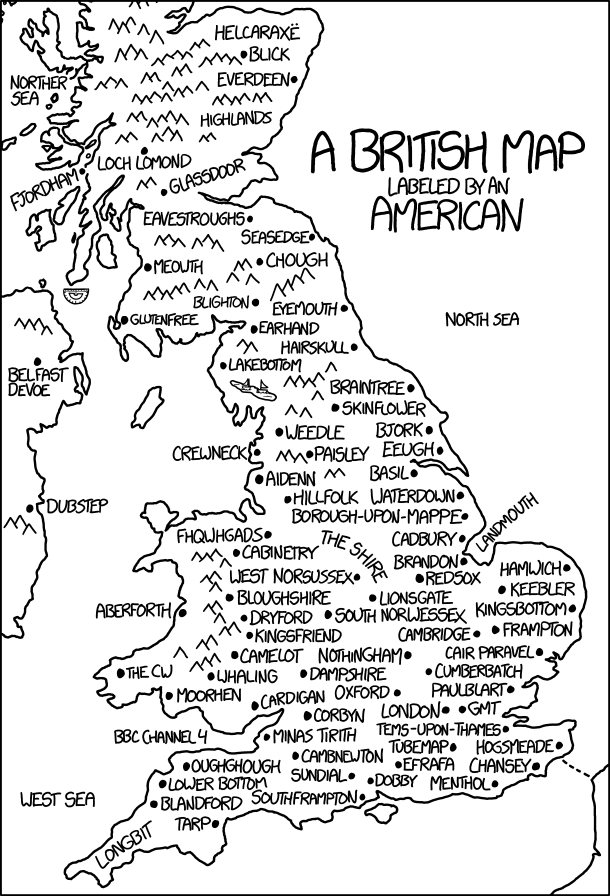
[A black-and-white map of Great Britain. The detail on the map is minimal, showing mainly the outlines of the land, chevrons representing otherwise sparse areas of high hills or mountains, and points representing cities. The only other features are a small drawing of a protractor south of one peninsula, a lake with two small sailboats on the west side of the largest landmass, and a short dashed line in the southeast connecting the main landmass to another section of land across water. The caption in the upper-right states in large letters “A BRITISH MAP,” then in smaller letters underneath, “LABELED BY AN AMERICAN.” Most of the map’s area is covered by labels for various features, which are listed below.]
[In Scotland, from north to south:]
Helcaraxë
Blick
Everdeen
Norther Sea (to the west)
Highlands
Loch Lomond
Fjordham
Glassdoor
Eavestroughs
Seasedge
Meowth
Chough
Blighton
Glutenfree
[In England, from north to south:]
Eyemouth
Earhand
Hairskull
Lakebottom
Braintree
Skinflower
Weedle
Bjork
Crewneck
Paisley
Eeugh
Aidenn
Basil
Hillfolk
Waterdown
Borough-Upon-Mappe
Cadbury
Landmouth (to the East)
The Shire
West Norsussex
Redsox
Hamwich
Lionsgate
Keebler
South Norwessex
Kingsbottom
Cambridge
Frampton
Nothingham
Cair Paravel
Dampshire
Cumberbatch
Oxford
Paulblart
Corbyn
London
GMT
BBC Channel 4 (to the West)
Minas Tirith
Tems-Upon-Thames
Tubemap
Hogsmeade
Cambnewton
Oughghough
Efrafa
Chansey
Sundial
Lower Bottom
Dobby
Menthol
West Sea (to the West)
Blandford
Southframpton
Tarp
Longbit
[In Wales, from north to south:]
Fhqwhgads
Cabinetry
Bloughshire
Aberforth
Dryford
Kingsfriend
Camelot
The CW
Whaling
Moorhen
Cardigan
[In Northern Ireland:]
Belfast Devoe
[In the Republic of Ireland:]
Dubstep